Much of this content appears in fragments elsewhere on this site, but it was an opportunity to write a brief precis of how the maps came about in one piece.
Letter Exchange piece.
In the two houses my parents lived in during my lifetime there hung, quite modestly on a landing or in a corridor, a small map and it’s reverse printing plate, sharing a frame. In a desk drawer lay some frayed, manilla envelopes containing maps, documents and photographs. When my parents died, the framed map and plate, and the manilla envelopes, came to me and lay in the same drawer to be infrequently bought out at the request of my children or of friends.
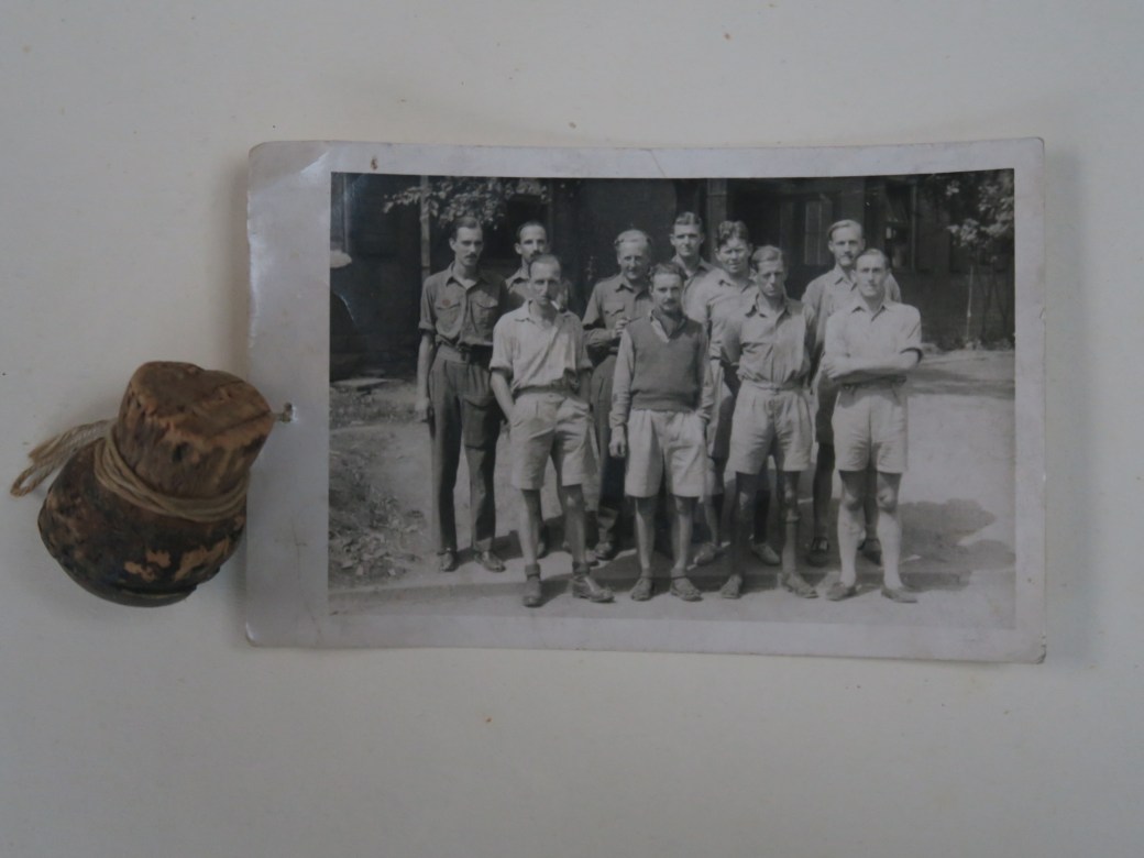
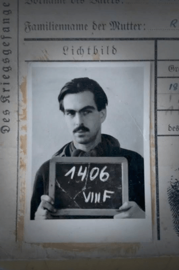
My father, Philip Radcliffe-Evans was born in Roby, near Liverpool in 1917, the youngest of three children. He was educated, not very happily, at Shrewsbury School, enrolled at the London School of Printing in about 1935 and had travelled to China on a merchant ship by the time he and his brother enlisted in the Royal Artillery in 1939, and at 21 he was a captain in command of a gun battery in N. Africa.

Philip Radcliffe-Evans on the right.
Of his time at the London School of Printing he wrote: “It was clear that the Depression had left the school starved of investment for re-equipment and the school was at least equally well equipped to teach the methods of the 1890’s as the 1930’s. I fear that this state of affairs suited my inclination exactly… The litho plant was admirably suited to this mentality. As I remember there were only 3 or 4 presses capable of accepting the new-fangled metal plates whereas there was a long row of stone transfer presses and an abundant supply of stones. It is no exaggeration to say that I used most of my time here…” These circumstances must have been crucial to his resourcefulness and inventiveness in Oflag 79 almost a decade later in 1944.
Like many of his generation, he spoke little of the war. In 1941 his older brother was killed, and the following year my father was captured by Italian forces at Tobruk, Libya. He and many other Allied troops were taken first to Chieti in Italy where they were held before being moved first to Stalag VII-A, Moosburg, Bavaria then Oflag-VIIIF, Mahrisch-Trubeau and finally to Oflag-79, Brunswick.

Oflag79 POW camp in 1945. A Former German paratroop barracks.
In August 1944 the Brunswick POW camp was hit by bombing from the Allied Air Forces. There were casualties and the kitchen and shower blocks were hit, damaged and partly destroyed. – “Late in August we had the big raid which was one of the most horrifying experiences I have had. Wave after wave of bombers came over dropping HE (high explosive) & anti-personnel bombs… three people were killed including poor old Kilkelly”.
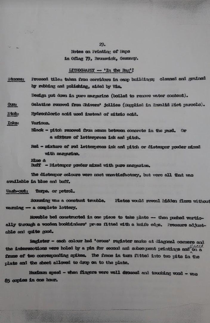
The prisoners were forced to use composite tiles from the shower blocks as plates to eat off. “While washing them I noticed that the grease left a pattern on the stone and, wondering at this familiar phenomenon, I tried grinding two tiles together – with sand and water between them. I became more than casually interested in them when I saw that the grease had actually been absorbed into the stone and a definite image had been formed. (This is the principle of lithographic printing)”.
He experimented with the stone tiles and margarine mixed with carbon for ink, and established that he could print and quickly saw how the process could be applied; – “One of the prime needs of an escape is a map, and hitherto these had been laboriously traced and (hand)copied by a dedicated number of cartographers. The originals printed on silk and designed to be concealed ‘about the person’ had been issued to certain personnel in England and a few had reached our camp in Brunswick. Apart from the increasing number of people wanting to “have a go” there was also growing concerns as to the possibility of the Russians arriving at Brunswick before the Allies, and the even nastier, and apparently not unfounded rumour, that the Gestapo were thinking of moving all POWs Eastwards. In either case plans for a mass breakout were being formulated”.
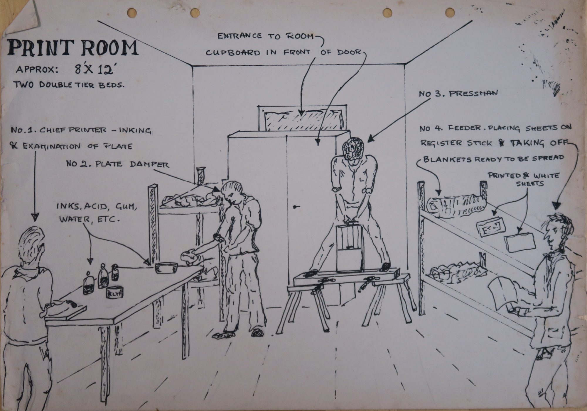
So he had stumbled upon a response to a need at a time of growing urgency. My father was a printer by trade, not a map maker or cartographer, and so what notes and information I have of his refer almost entirely to the technical problems of building a press from scratch, making inks and maintaining secrecy, though there is a reference to his being given access to two cartographers (fellow POWs) through the “escape committee”. There were 4 different maps produced, 1200 in all, so it was a press with a purpose and was a mass production process. They are all printed on thin, utility paper, stolen from German admin offices, and are all roughly similar in size, varying from 280mm x 220mm to 220mm x 190mm.
After much practical experimentation in the Autumn of 1944, processing and inks utilised crushed leads of indelible pencils, bitumen scraped from the joints between floor tiles, fountain pen inks, Chiver’s jelly, powder paint, molten margarine and and small quantities of acid obtained illicitly from medical supplies. The machine was constructed from floor boards, packing case parts, window bars, leather from an old flying jacket and parts of a simple book binding press obtained via the Red Cross, supposedly for the maintenance of books in the camp library, also sent in supply parcels. My father and fellow printer, Ken Whitworth, trained six other prisoners and ran two shifts of four men each, producing up to 60 maps an hour.
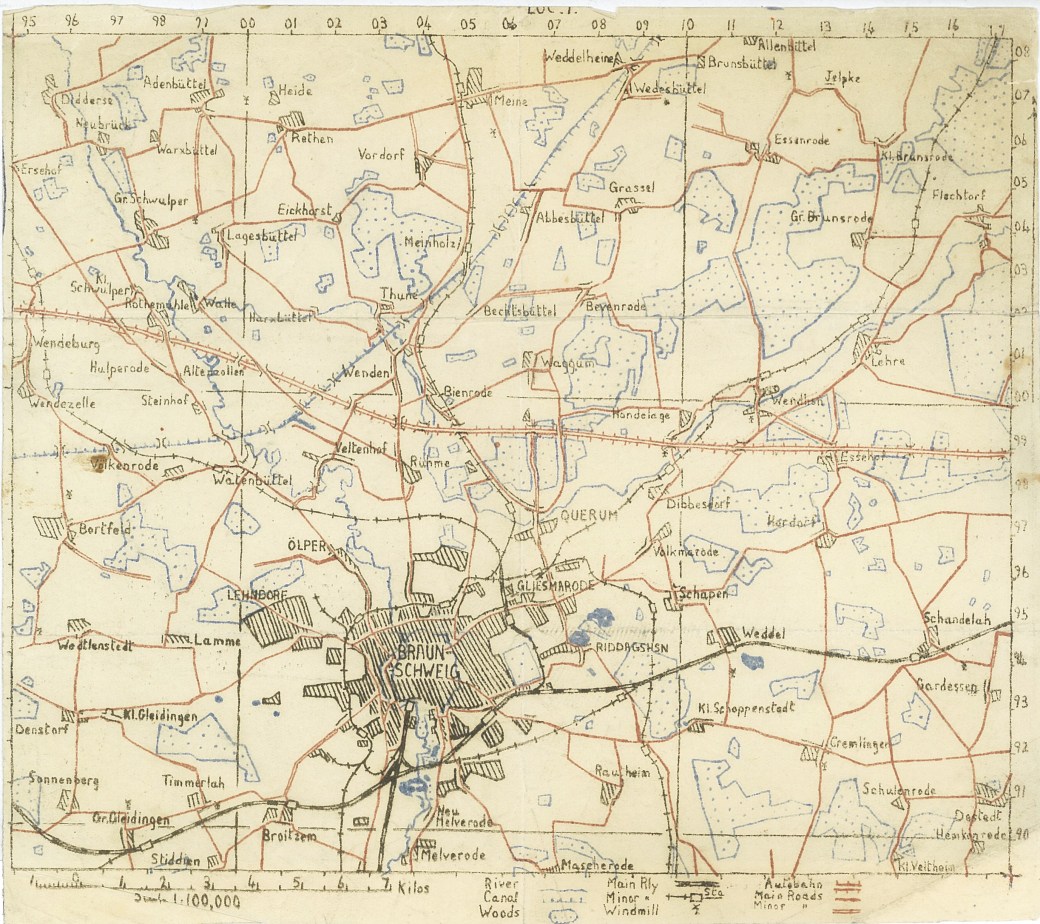
The maps were made to three different scales; the largest scale map is of Oflag-79 camp and its perimeter at 1:10,000; 100 were printed and it is the largest in actual size – “Much of the information on which this had been based came from a local map obtained by our “fixer:”, but a good deal had been observed by temporary, and, as far as I know, unobserved escapees who had been out on reconnaissance”. It has a grid lettered on vertical and horizontal axes and numeral coordinates within each square and has a short text notation. In three colours it shows the camp in relation to the Magdeburg – Hanover railway line to the North, the River Schunter to the South and its relationship to the village of Querum. It is easily possible to find the exact location of what was Oflag-79 by comparing this map to Google maps and Google Earth.
1:10,000 three colour map of Oflag79 and immediate surroundings with an overlay onto Google Earth.
I had thought that the camp was demolished at some point soon after the war, but in correspondence with Andreas Eberhard of the local Braunschweiger-Zeitung newspaper he has said that “Oflag 79 was sort of rediscovered by local historians in Braunschweig only a few years ago. For many years it was almost forgotten in the public memory of our town. From 2010 on, some research was done. Now there is a book and several newspaper articles about the camp”. It is currently used to house refugees (2017).
The next largest scale map is a 1:100,000 three colour map of the Brunswick area. It is 230mm x 200mm in size, 100 were printed. It is gridded into six principle squares with numerical coordinates along the top and down the right hand side. Along the bottom it has a scale and a simple key with principle features; rivers, canals, woods, railway lines, windmills, autobahns, main and minor roads. Oflag-79 is central, just NNE of Braunschweig. This would have been copied from one of the clandestine maps that came into the camp, often printed on silk and hidden in the cover of a book or Monopoly board; ones which previously would have been copied laboriously by hand one at a time.
1:100,000 three colour map of Braunschweig and routes North.
The two remaining maps are the smallest scale at 1:1,000,000 and can be joined vertically, making up North and South sections. The southern map places Brunswick to the East, Osnabruck to the West and Kassel to the South. It is simply gridded into almost six squares marked by degrees of latitude and longitude. It has a kilometre scale at the top, and a key that is slightly more thorough than the 1:100,000 map, and a note of Magnetic Variation – 5°. It is the only map printed in four colours. My father wrote: “We added a fourth colour to this, a yellow for major mountain ranges. A total waste of time and effort but I think we had become technically vain-glorious…”
The northern map of this pair, with similar notation, covers Luneburg and the ports of Hamburg and Bremen with the sea and estuaries depicted in a shade of blue that is still beautifully vivid 70 years on.
1:1,000,000 maps with southern and northern sections enabling escapes to be made to the North coast ports Hamburg and Bremen.
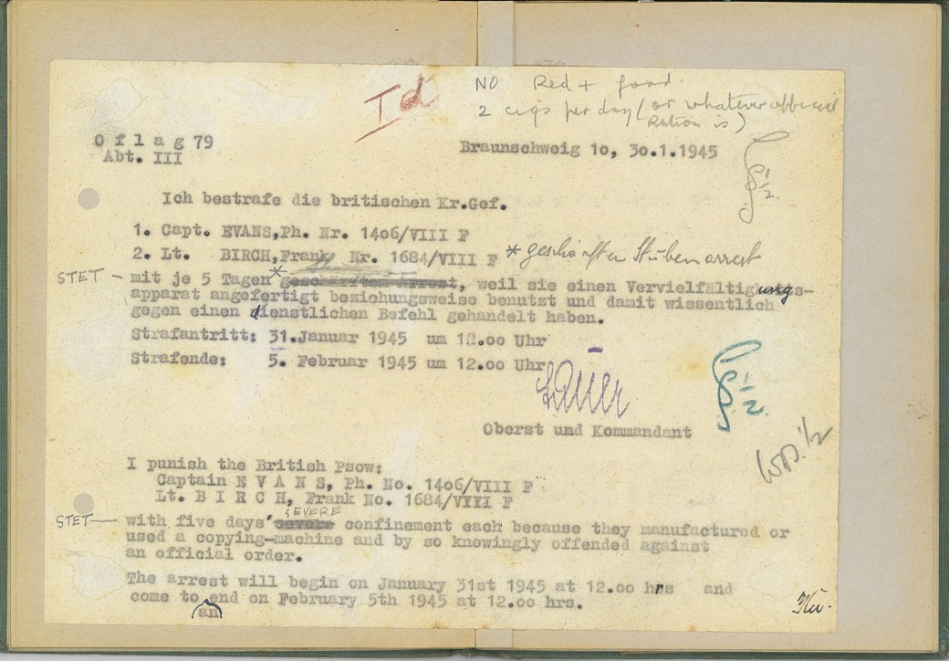
On 30th January 1945 my father and another prisoner were caught working on a printing plate, the press was destroyed, as were a number of completed maps, and they were sentenced to solitary confinement and limited rations. Oflag-79 was liberated on 12th April 1945.
People often ask how many were used and with what success. More than 70 years later it is impossible to say, though I am in touch with the family of another prisoner involved in the press, Wallis Heath, who still have copies of the maps. My father wrote in around 1950 “I would like to be able to claim that our maps were responsible for escapees getting home, and I’m sure that they did but there are no statistics. Certainly they were issued to those who were allowed to try between January and April 1945 and it is really sad that we had not discovered the possibilities of the process a little earlier”.
In 2014, I met, completely by chance, Ken Burnley, who had been an apprentice in my father’s printing firm, Tinlings of Liverpool, in the 1960’s. Ken is now retired and runs a letterpress studio in Liverpool, teaching letterpress and producing limited editions. He remembered my father both well and fondly. I told him about the maps, of which he was unaware, and he asked me to bring them next time we met. We laid everything out on the table and after a minute he said “We have to do a letterpress book about this!” – and so The Brunswick Prison Camp Map Printers came about.
The Brunswick maps are an extraordinary technical achievement, wonderful objects, and form a small part of both WW11 and printing history. The excerpts here come from my father’s POW diary, an article he wrote for Printing Review in 1951 and type-written notes for a talk he gave around the same time. In their entirety, these, with other archive material in my possession, have the basis for a more comprehensive publication in the future.
Mark R. Evans. August 2017.
Extracts from Philip Radcliffe-Evans notes, POW diary and Printing Review article 1951.
https://thebrunswickprinters.com


 Two or three months ago I was contacted by Andreas Eberhard, a journalist on Braunschweiger Zeitung, the Brunswick local newspaper, who had come across the Twitter page for The Brunswick Printers. We e-mailed, had a phone conversation, and then spent most of a morning on Skype. He was hugely and very genuinely interested in the story, and it was a strange and poignant experience to be talking to him in this way and in effect taking the story back home.